Speaking of maps, let me tell you a map story...
(If you don't want to read the story, skip to the high-res scans.)
When I was a kid, I saw these posters up in a high school classroom:
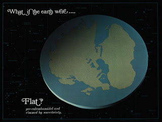 |
| A flat Earth |
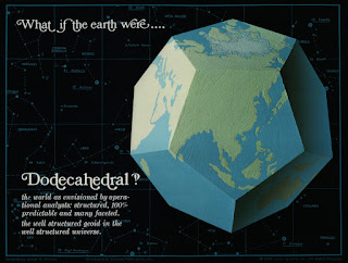 |
| A dodecahedral Earth |
...and ten more. Twelve images of fantastical Earths, each with a gnomic rumination on its shape.
What did they mean? Why were they there? They were clearly some kind of exercise in imaginative physics, but that's all I knew. I was somewhat obsessed with the tag lines, though. And the interrobangs.
Years later, I discovered the images on the web site of Litton Guidance & Control Systems. (Wayback link; the web site is defunct.)
This site told the story:
Earthshapes is a series of 12 hypothetical Earths as conceived by Joseph N. Portney in 1968 during a flight to the North Pole onboard a U.S. Air Force KC-135. The aircraft was equipped with dual Litton LTN-51 Inertial Navigation Units that were the primary navigation source for the flight. As the North Pole was reached, Portney looked on the icy terrain below and mused to himself, "What if the Earth were......?" The results of this imaginative lapse were the Earthshapes. The 12 hypothetical Earths were then sketched and captioned by Portney and given to the Litton Guidance & Control Systems graphic arts group to create the models. They were then photographed and became the theme of a Litton publication entitled Pilots and Navigators Calendar for 1969. Each month was introduced with a different one of the 12 hypothetical Earths. The calendar was an international sensation, receiving awards and heavy fan mail. To satisfy customer demand it was reprinted as a fiscal calendar.
Earthshapes was used on the cover of the U.S. Air Force publication The Navigator, displayed at the Los Angeles Central Library, appeared on TV, developed as an educational publication and referenced in math texts. Earthshapes has been shown in classrooms throughout the world by students and instructors for 27 years.
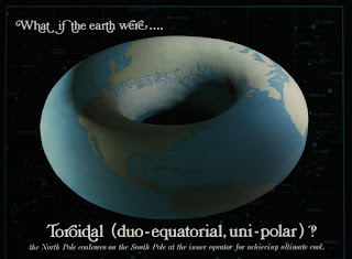 |
| A toroidal Earth |
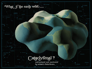 |
| A cataclysmal Earth |
A couple of years after that -- this was probably 2000 -- I was wandering through an educational supply store. The same place I got these dice, come to think of it. And behold! A package of "Earthshapes posters" from the Ideal School Supply Company. You better believe I bought them on the spot.
The package gave a few more details:
A modern navigation problem involves the safe guidance and control of high altitude, long-range aircraft (both military and commercial). Joseph N. Portney has been involved in solving this problem since joining Litton Guidance and Control Systems in 1960. He graduated from the U.S. Naval Academy and served as a navigator-bombardier in the U.S. Air Force. Mr. Portney has participated in the development of several inertial navigation systems and has aligned and tested several of these systems on flights over the North Pole. To show the capabilities of one of these navigational systems, Mr. Portney began to think, "What if the Earth were..." and the odd shaped models shown on the posters resulted. Merely by reprogramming the guidance system's computer, a plane could be guided safely over and around the odd curves and corners of different worlds.
That pamphlet is dated 1976 (copyright Creative Publications), but the posters themselves say "Designed by Joseph N. Portney; copyright 1969 by Litton Systems." I suspect that the star-chart background was added specifically for the posters, but without seeing the 1969 calendar it's impossible to be sure.
By the way, modern readers may not grasp how strange these images are. 1969 is pre-CGI! Somebody (I guess a Litton artist?) modelled them, I don't know, in plaster? Wood? And then painted the continents and ice caps! You can see they used thick green paint to provide just that little bit of terrain relief.
I'm pretty sure they used geometrically accurate projections to map the spherical Earth to each shape. Map projections was Portney's whole job. Anyone have software to project a sphere map onto a cube or cylinder? I'd love to see if they match up.
(The Wegeneroidal Earth isn't a projection; it just rearranges the modern continents to be closer together. Not an accurate reconstruction of Pangaea, of course, but it illustrates the idea.)
Anyway, there matters sat. Until...
A few months ago, I noticed that the Litton web site was dead. Litton had been acquired by Northrop Grumman in 2001, so it had been dead for years, really.
Earthshapes persisted on the web in a few places. A site called Navworlds has info about Portney and the Earthshapes. It seems to be a personal site created by (or for) Portney late in life. There's also a math page at Cambridge, although it doesn't seem to have been updated for many years.
(Interesting note: the Cambridge site seems to have a later edition of the posters: "copyright 1998". Two of them have additional footnotes. They're also brightened up, with the ice caps rather painfully blown out.)
Here's the thing, though. None of these sites -- not even Portney's own -- has good copies of the Earthshapes. Nothing high-resolution. The best images I could find were 750 pixels wide or so.
Wait, didn't I still have...somewhere in the back of my closet...
I had to dig up an A3-format scanner, but now the job is done. Behold: Earthshapes, the 1976 edition, scanned at 600 dpi. (Internet Archive link.) Also includes the educational pamphlet.
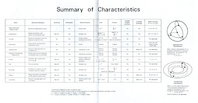 |
| Chart from the pamphlet |
Yes, I am skirting copyright here. The formal rights to these posters must be buried somewhere in Northrop's legal vaults. The Navworlds site is probably the moral heir, and it's quite recent. (Seems to have gone up in August 2022.)
But, again, high quality images. There just weren't any. Other collectors might have physical copies of these posters; there are a few in university libraries. But nobody else was scanning. So I scanned.
One more mystery. The Navworlds Portney bio page says:
Joe created Earthgrids and Earthshapes that became award winning Pilots' and Navigators' Calendar-Atlas'.
...Earthgrids? Earthgrids?
I can't find a single trace of "Earthgrids" outside that one mention. (There's an ignorable New Age book, no relation.)
Anybody know?
